
An important weather announcement has just been released for the greater Pittsburgh region. The National Weather Service (NWS) in Pittsburgh has issued a Tornado Watch in effect until 8:00 PM tonight. In addition to the tornado risk, the area is expected to see heavy rainfall and strong wind gusts, which could bring hazardous conditions across multiple counties.
This storm system is capable of producing fast-moving, potentially damaging thunderstorms. With the combination of high winds and rapidly changing atmospheric conditions, the chance for tornadoes remains elevated through the evening hours. Wind gusts may reach speeds upwards of 50–60 mph, and rain accumulation could be significant in a short period of time.
Flood Watch in Effect:
As if the tornado watch weren’t enough, a Flood Watch has also been issued and will remain in effect through the early morning hours tomorrow. The heavy rainfall associated with this storm could lead to flash flooding, especially in low-lying and poor drainage areas, creeks, streams, and urban roadways. Motorists are strongly advised to avoid flooded roads — remember, “Turn Around, Don’t Drown.”
Authorities urge residents to stay tuned to local alerts and updates. Make sure cell phones are charged, weather radios are operational, and emergency plans are reviewed, especially if you live in flood-prone or tornado-vulnerable areas.
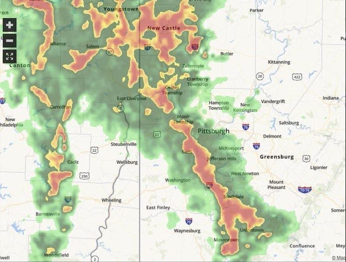
Now, on a lighter but oddly accurate note — the storm cell currently hovering over the area looks a bit like the country of Italy. That’s right — in a moment of levity during a tense weather situation, my wife pointed out that the shape of the storm on radar resembles the boot-shaped peninsula of Italy. And honestly? She’s not wrong. So, if you see that boot-shaped blob moving across your radar apps — just know that’s our very own “Storm Italy” making its mark over western Pennsylvania.
While we can appreciate a little humor in tough times, this is a serious weather situation. Please take all precautions necessary to keep yourselves, your families, and your communities safe.
What You Should Do Now:
- Monitor alerts from the NWS and local authorities.
- Secure outdoor objects that could be blown away.
- Prepare a safe room or shelter space in case a tornado warning is issued.
- Avoid travel if possible during the watch and into the overnight hours.
- Be prepared for power outages.
Stay safe out there — and yes, keep an eye on the Italian boot moving through the skies.