
WEDNESDAY SEVERE STORM THREAT ACROSS CHICAGOLAND: Stay Weather Aware
SEVERE WEATHER ALERT – A powerful line of storms is expected to sweep through the Chicagoland region on Wednesday afternoon and evening, bringing with it the potential for damaging winds, large hail, and isolated tornadoes. Residents are urged to remain vigilant and prepared as atmospheric conditions become increasingly volatile.
TIMING
- The severe weather window opens Wednesday afternoon and lasts through the evening hours.
- Storms may begin developing early in the afternoon, with the most intense activity expected between 3:00 PM and 9:00 PM.
HAZARDS
- Damaging Wind Gusts: Straight-line winds could exceed 60 mph in the strongest storms, capable of downing trees and powerlines.
- Large Hail: Some storms may produce hail larger than 1 inch in diameter, which could damage vehicles, roofs, and crops.
- Tornado Risk: A 5% tornado risk has been issued by the Storm Prediction Center (SPC) for parts of the region, especially in the southeastern counties. While this may sound low, it is a meaningful and serious threat in meteorological terms.
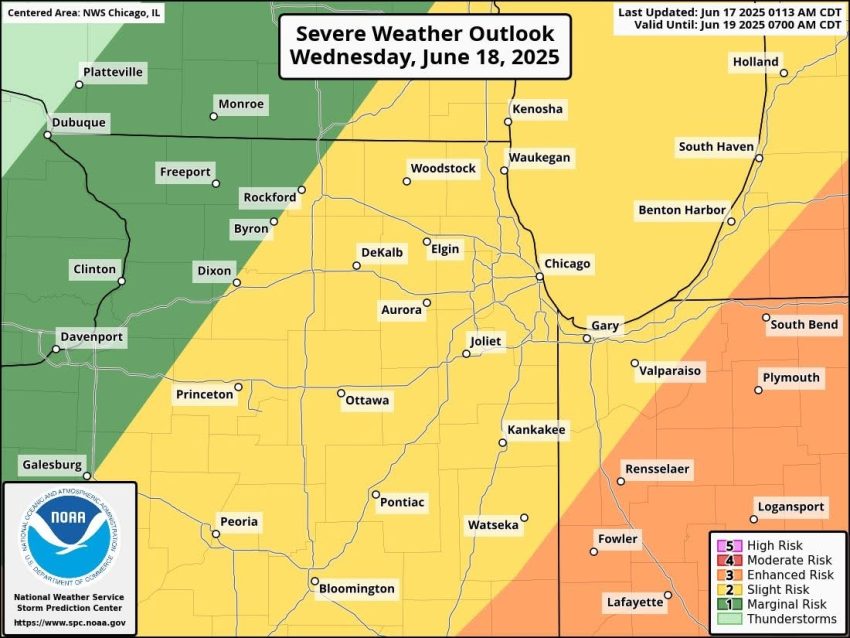
According to SPC outlooks:
- Most of the metro area falls under a Slight Risk (Level 2 of 5), indicating the potential for scattered severe storms.
- Far southeastern counties (including areas closer to Kankakee, Watseka, and parts of northwest Indiana) are under an Enhanced Risk (Level 3 of 5), where the environment is more supportive of stronger and more widespread severe weather.
TORNADO THREAT DETAILS
- Areas shaded in brown on SPC’s tornado risk map face a 5% probability of a tornado occurring within 25 miles of any location within that shaded zone.
- While that may seem small, it signals a significant uptick in risk compared to normal days in the region.
PREPAREDNESS TIPS
- Enable Wireless Emergency Alerts (WEA) on your phone.
- Download a trusted weather app and keep your device charged.
- Have multiple ways to receive warnings, especially if you’ll be away from TV or radio.
- Secure outdoor furniture or items that could become projectiles in high winds.
- If watches or warnings are issued, take them seriously and be prepared to move to a safe location quickly.
BOTTOM LINE
Wednesday brings a real and potentially dangerous threat of severe weather across northern Illinois and northwest Indiana. The combination of daytime heating, atmospheric instability, and wind shear makes this a setup that can’t be ignored.
Please stay tuned for updates from trusted meteorologists, local officials, and the National Weather Service as the forecast evolves. A few hours of preparation could make all the difference.
I’ll continue to post updates as necessary through Wednesday morning and afternoon. Stay safe, Chicagoland!